
Chapter 7 Test Review
Instructions: There are 65 review questions on this page. Click on the button with the answer that you think is correct. Keep track of how many you get correct on the first try, divide that number by 65, and then multiply by 100, and that will be your grade had this been the actual test.
Base your answers to questions 1 to 2 on the map below which shows high pressure and low pressure weather systems in the United States.
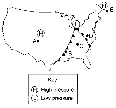
A and B
B and D
C and E
A and D
A and B
B and C
C and D
A and D
![]()
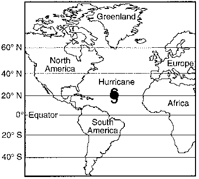
From the position shown on the map, toward which landmass is the hurricane most likely traveling?
North America
South America
Europe
Africa
![]()
Base your answers to questions 4 and 5 on the diagram below, which shows the frontal boundary between mT and cP air masses.
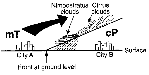
The warm air rises, expands, and cools.
The warm air sinks, expands, and warms.
The cool air rises, compresses, and cools.
The cool air sinks, compresses, and warms.
occluded front
stationary front
cold front
warm front
![]()
Use the station model below to answer questions 6 through 17. The station model below shows the weather conditions at Massena, New York at 9 a.m. on a particular day in June.

What is the current air temperature?
75°F
74°F
54°F
540°F
75°F
74°F
54°F
540°F
Sleet
Rain
Drizzle
Hurricane
74 miles
0.25 miles
540 miles
1.5 miles
The northeast
The northwest
The southeast
The southwest
-21 inches
1.5 inches
0.25 inches
74 inches
15 knots
540 knots
4.5 knots
35 knots
35.00 miles per hour
36.15 miles per hour
30.43 miles per hour
40.25 miles per hour
540 mb
954.0 mb
1054.0 mb
154.0 mb
It was falling 21 mb over the last 3 hours.
It was falling 2.1 mb over the last 6 hours.
It was rising 2.1 mb over the last 6 hours
It was falling 2.1 mb over the last 3 hours
933.0 mb
975.0 mb
956.1 mb
951.9 mb
933.0 mb
975.0 mb
956.1 mb
951.9 mb
![]()
from the northeast to the southwest
from the northwest to the southeast
from the southeast to the northwest
from the southwest to the northeast
cool land
cool water
warm land
warm water
cP is from the North Atlantic Ocean and mT is from the deserts of the southwestern United States.
cP is from northern Canada and mT is from the deserts of the southwestern United States.
cP is from northern Canada and mT is from the Gulf of Mexico.
cP is from the North Atlantic Ocean and mT is from the Gulf of Mexico.
warm and dry.
cold and dry.
warm and moist.
cold and moist.
mP.
mT.
cP.
cT.
Central Canada
Central Mexico
Gulf of Mexico
North Pacific Ocean
colder and contains more moisture.
colder and contains less moisture.
warmer and contains more moisture.
warmer and contains less moisture.
mP
mT
cP
cT
Central Canada
Central Mexico
Gulf of Mexico
North Pacific Ocean
lower temperature and more water content.
lower temperature and less water content.
higher temperature and more water content.
higher temperature and less water content.
mP.
mT.
cP.
cT.
size of the air mass.
characteristics of the surface over which the air mass was formed.
rotation of the Earth.
wind speed within the air mass.
evaporation.
volcanic activity.
precipitation.
transpiration.
1,023 mb
1,020 mb
1,017 mb
1,015 mb
Good Optical Eye Satellite
Great Orbiting the Earth in Space satellite
Geostationary Operational Environmental Satellite
Gets Only Earth Satellite
Government Occupies Everything even in Space satellite
equally accurate.
more accurate.
less accurate.
ocean currents.
seismic data.
phases of the Moon.
air mass movements.

Weather conditions in which location would be of most interest to a person predicting the next day's weather for New York State?
A
B
C
D
![]()
Base your answers to questions 36 through 41 on the weather map below, the Earth Science Reference Tables, and your knowledge of Earth science. The map shows a high-pressure center (H) and a low-pressure center (L). Isobars are labeled in millibars.

continental polar air mass that originated in central Canada.
maritime polar air mass that originated over the Gulf of Mexico.
continental tropical air mass that originated in the Arctic region.
maritime tropical air mass that originated over the Atlantic Ocean.
Air above this region is sinking and cooling, and water vapor is evaporating.
Air above this region is sinking and warming, and water vapor is evaporating.
Air above this region is rising and cooling, and water vapor is condensing.
Air above this region is rising and warming, and water vapor is condensing.
northern Maine
northwestern Ohio
central Tennessee
southeastern New York State
The fastest surface winds are always located around a low-pressure system.
The isobars are closer together in that region than in others.
The fastest surface winds always follow the typical storm track.
The isobars are thicker there.
northwest.
northeast.
southwest.
southeast.
clockwise and toward the center.
clockwise and away from the center.
counterclockwise and toward the center.
counterclockwise and away from the center.
![]()
Base your answer to questions 42 through 44 on the weather map of North America below. The map shows the location of a front and the air mass influencing its movement.
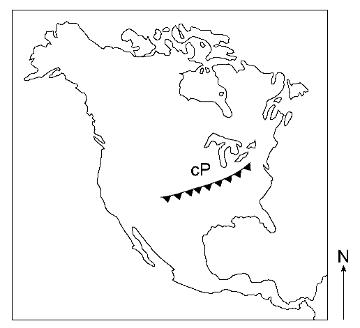
Which region is the probable source of the air mass labeled cP on the map?
central Canada
southwestern United States
North Atlantic Ocean
Gulf of Mexico
cold front moving northwestward
cold front moving southeastward
warm front moving northwestward
warm front moving southeastward
wind direction.
cloud cover.
moisture content.
wind speed.
![]()
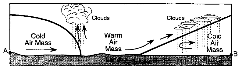
Use the diagram below for questions 45 through 46, which represents a cross section of air masses and frontal surfaces along line AB. The dashed lines represent precipitation.

cold front
occluded front
stationary front
warm front
![]()
Base your answers to questions 47 through 50 on the Earth Science Reference Tables and the data table below. The table shows weather conditions for 4 consecutive days at a location in New York State. Each reading was taken at 1 p.m.
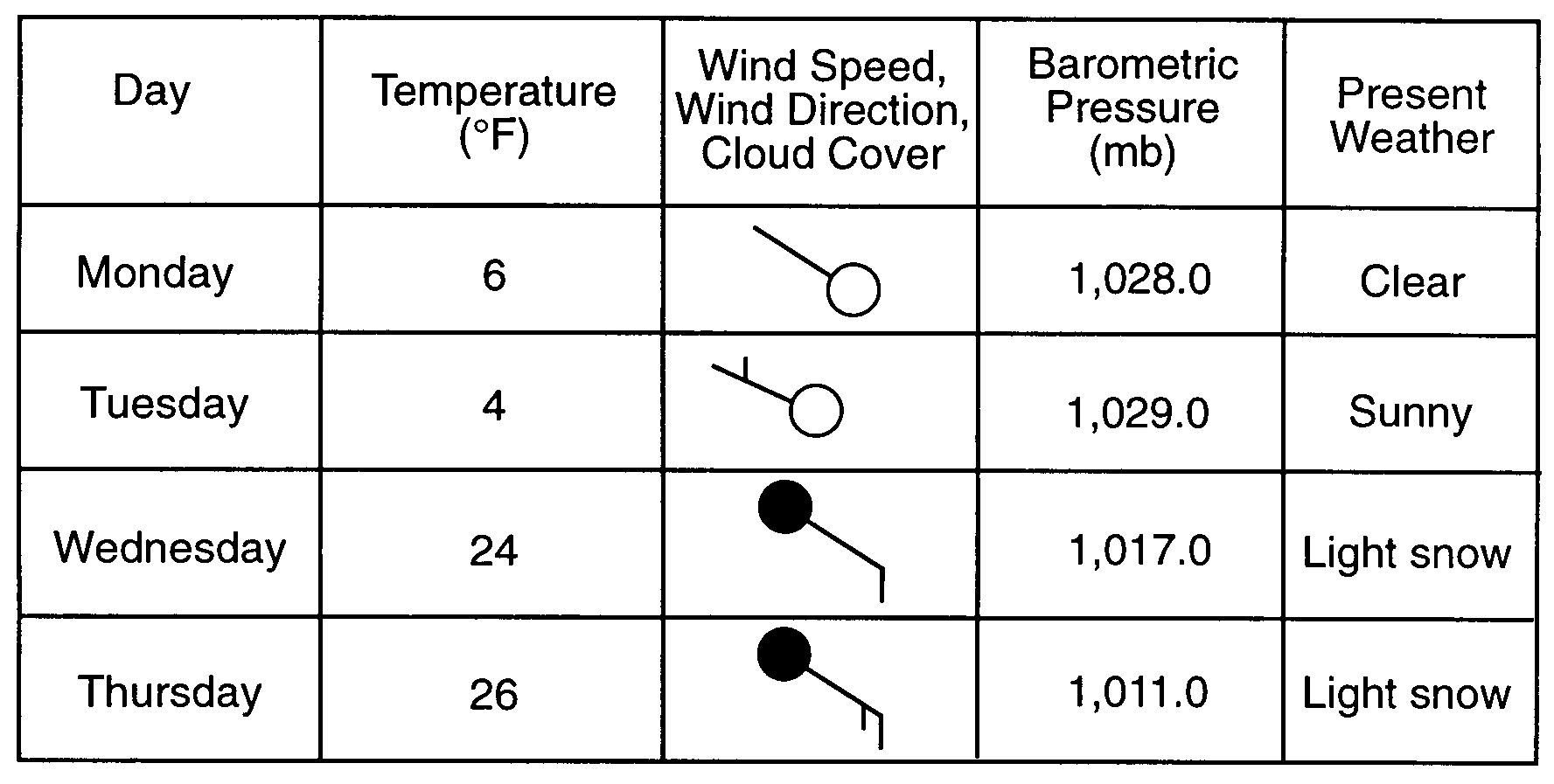
Monday
Tuesday
Wednesday
Thursday
cP
cT
mP
mT
![]()
![]()
![]()
![]()
20 °F.
28 °F.
36 °F.
4 °F.
![]()
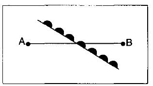
Use the profile of the following front to answer questions 51 through 56.
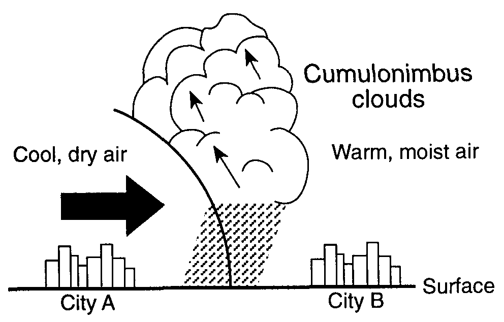
cold front
occluded front
stationary front
warm front
City A
City B
Both City A and B
Neither city
cP
cT
mP
mT
cP
cT
mP
mT
Hail
Long periods of gentle rain and drizzling
Short periods of heavy rain and thunderstorms
Tornadoes
Lower temperatures and a lower relative humidity.
Lower temperatures and a higher relative humidity.
Higher temperatures and a lower relative humidity.
Higher temperatures and a higher relative humidity.
![]()
condensation
evaporation
precipitation
infiltration
expanding air.
condensation nuclei.
condensing water vapor.
falling precipitation.
241 mb
924.1 mb
1,024. mb
9,241.0 mb
energy is given off.
energy is absorbed.
the total amount of energy remains the same.
A high-pressure system
A hurricane
A low-pressure system
A tornado
anticyclone.
cyclone.
typhoon.
tsunami.
Approximately 60° to 66.5° north latitudes and off the east coast of Greenland.
Around central Canada and over land.
Approximately 5° to 15° north of the Equator and off of the west coast of Africa.
Approximately 5° to 15° north of the Equator and off of the west coast of Mexico.
They move to warmer climates and over drier water, which cuts off its "fuel" source.
They move to colder climates and over drier water, which cuts off its "fuel" source.
They move to warmer climates and over drier land, which cuts off its "fuel" source.
They move to colder climates and over drier land, which cuts off its "fuel" source.
Better than 90%
Between 70% and 90%
Between 50% and 70%
Less than 50%