
Instructions: Click on the button to see if your answer is correct or not. I recommend keeping track of how many you get correct on your first try.
![]()
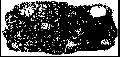
1. The map below shows the path of an ash cloud that resulted from the Mount St. Helens volcanic eruption. The map was developed from satellite photographs.
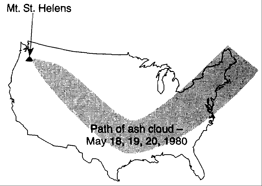
The path of the ash cloud was most probably determined by
theory.
hypothesis. observation.
inference.
![]()
2. In the classroom during a visual inspection of a rock, a
student recorded four statements about the rock. Which
statement about the rock is an observation?
The rock formed deep in the Earth's interior.
The rock cooled very rapidly.
The rock dates from the Precambrian Era.
The rock is black and shiny.
3. Measurements of gravity are greater at the poles than at the
Equator. This evidence best supports the inference that Earth
has a
slightly oblate shape.
slightly elliptical orbit.
perfectly spherical shape.
very elliptical orbit.
4. Which diagram most accurately shows the cross-sectional
shape of the Earth?
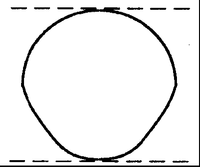
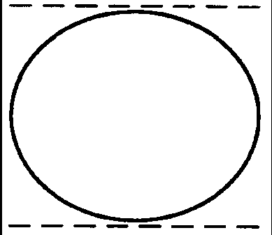
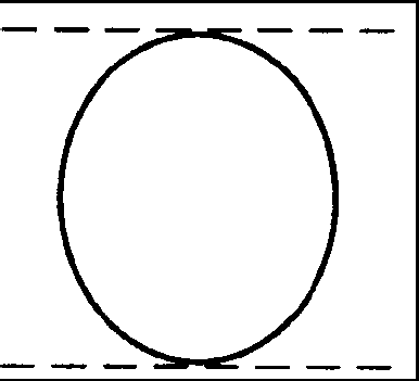
![]()
Base your answers to questions 5 through 9 on the Earth Science Reference Tables, the diagrams below, and your knowledge of Earth science. The diagrams represent two different solid, uniform materials cut into cubes A and B.
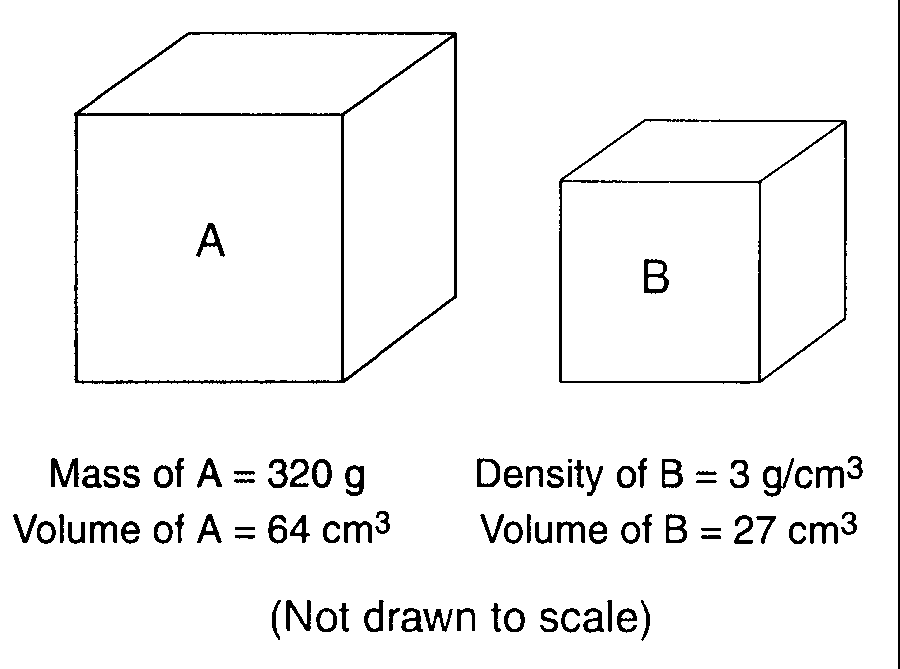
5. If cube B was dropped into water, it would
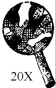
float along the top of the water.6.
A student calculates the density of a third material as 10.4
grams per cubic centimeter instead of the accepted value of
8.0 grams per cubic centimeter. What is the student’s
approximate percent deviation (percent of error)?
3.8%
3.0%
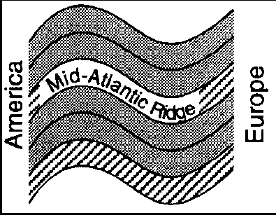
30.0%
36.1%
7. What is the density of cube A?
0.2 g/cm3
5.0 g/cm3
12.8 g/cm3
64.0 g/cm3
8. What is the mass of cube B?
9 g
3
g
27 g
81 g
9. Assume cube B was broken into many irregularly shaped
pieces. Compared to the density of the entire cube, the
density of one of the pieces would be
less.
greater
the same.
![]()
10. If a parcel of air is cooled, its density will
decrease.
increase.
remain the same.
11. Which object best represents a true scale model of the shape
of the Earth?
a Ping-Pong ball
an egg
a football
a pear
12. Precise measurements of the Earth indicate that its polar
diameter is
shorter than its equatorial diameter.
longer than its equatorial diameter.
the same length as its equatorial diameter.
13. The diagrams below represent photographs of a large sailboat taken through a telescope over time as the boat sailed away from shore out to sea. Each diagram shows the magnification of the lenses and the time of day.
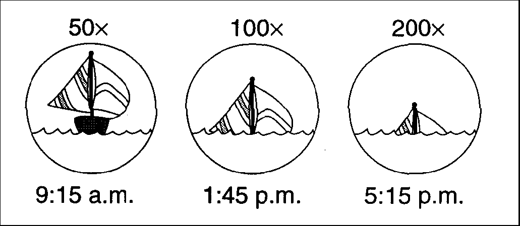
Which statement best explains the apparent sinking of this sailboat?
The tide is causing an increase in the depth of the ocean.
The change in density of the atmosphere is causing refraction of light rays.
The sailboat appears smaller as it moves farther away.
The sailboat is moving around the curved surface of Earth.
14. The best evidence that the Earth has a spherical shape is provided
by
the amount of daylight received at the North Pole on June 21
photographs of the Earth taken from space satellites
the cyclic change of seasons
the changing orbital speed of the Earth in its orbit around the Sun
15. Earth’s troposphere, hydrosphere, and lithosphere contain
relatively large amounts of which element?
potassium
oxygen
hydrogen
iron
16. Earth's hydrosphere is best described as the
solid outer layer of Earth
liquid outer layer of Earth
magma layer located below Earth's stiffer mantle
gaseous layer extending several hundred kilometers from Earth into space
17. When the time of day for a certain ship at sea is 12 noon, the time
of day at the Prime Meridian (0° longitude) is 5 p.m. What is the ship’s
longitude?
45° E
75° E
45° W
75° W
18. Which rock type is most likely to be monomineralic?
conglomerate
rhyolite
basalt
rock salt
19. Use the image below to answer the following question.
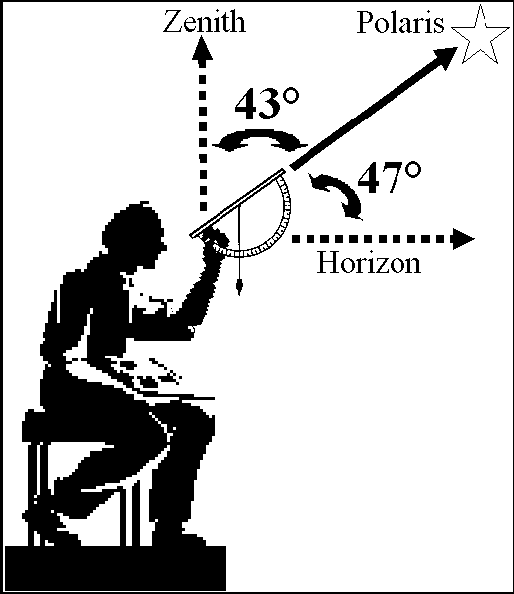
What is the latitude of this observer?
47º South
43º South
47º North
43º North
20. Which feature is characteristic of sedimentary rocks?
glassy texture
foliation
distorted structure
layering
21. Which group lists rocks in order by grain size from smallest to
largest?
shale, sandstone, conglomerate
shale, conglomerate, sandstone
conglomerate, sandstone, shale
sandstone, shale, conglomerate
22. According to the Earth Science Reference Tables, particles of which
size could have formed silt?
0.0002 cm 0.02 cm
0.002 cm
0.2 cm
![]()
Base your answer to questions 23 to 24 on the geologic cross section below, which shows limestone that was intruded. Part of the limestone (zone A) was heated intensely but was not melted.
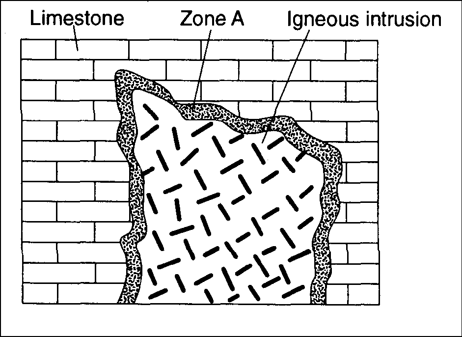
23. Which rock is most abundant in Zone A?
Quartz
Limestone
Calcite
Marble
24. Which mineral is most abundant in Zone A?
Quartz
Limestone
Calcite
Marble
![]()
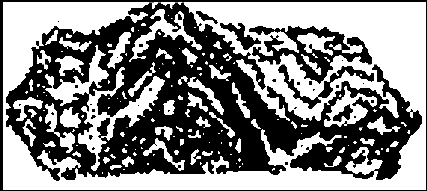
25. Which sample best shows the physical properties normally associated
with regional metamorphism?
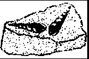
26. In which of the following rocks might you find fossils?
Limestone
Gneiss
Granite
Slate
.
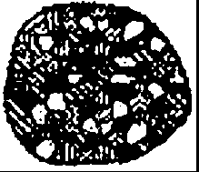
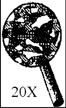
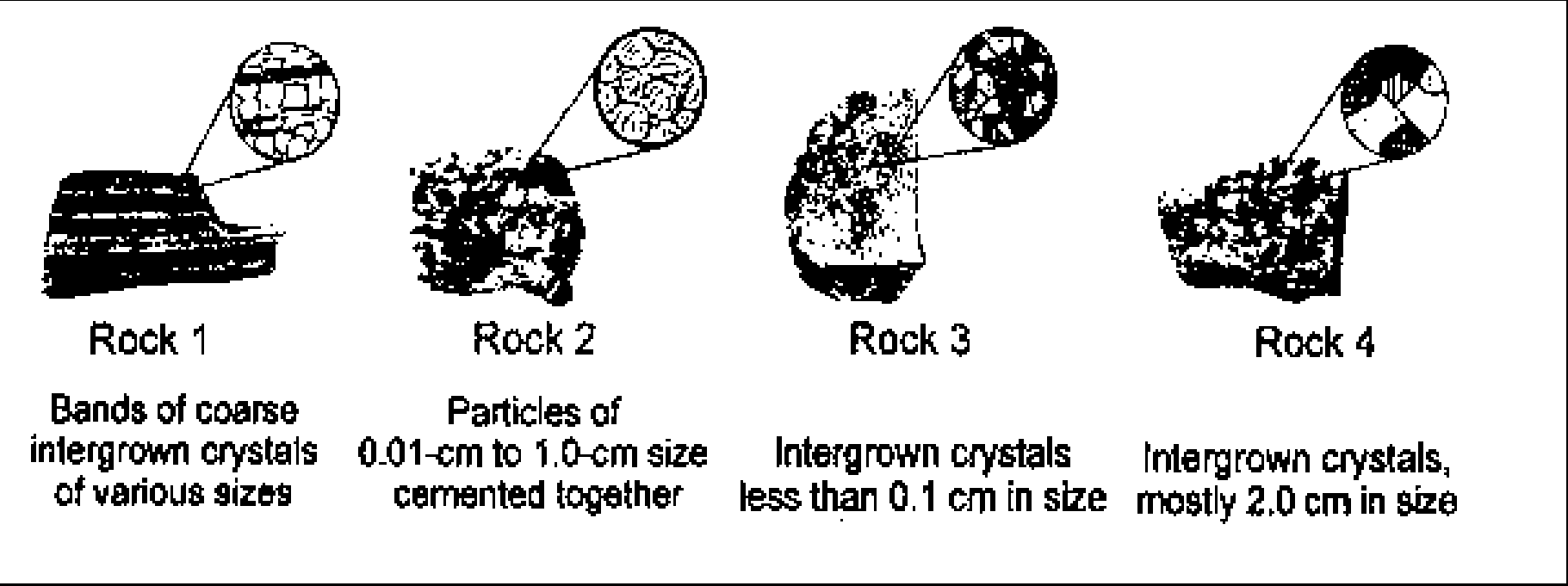
27. The diagrams below show the crystals of four different rocks viewed
through the same hand lens. Which crystals most likely formed from molten
material that cooled and solidified the slowest?


28. A clastic sedimentary rock that has many different grain sizes, from
clay-sized to gravel-sized, “cemented” together, where the majority of the
fragments are rounded in shape is:
breccia.
metaconglomerate.
conglomerate.
basalt.
29. Compared to felsic igneous rocks, mafic igneous rocks contain
greater amounts of
aluminum
iron
white quartz
pink feldspar
30. A mineral’s crystal shape and cleavage are a direct result of the
mineral’s
exposure to the hydrosphere and atmosphere
arrangement of atoms
abundance in nature
hardness
31. Which of the following is located at a diverging plate boundary?
Sandwich Plate
Iceland Hotspot
Marianas Trench
Southwest Indian Ridge
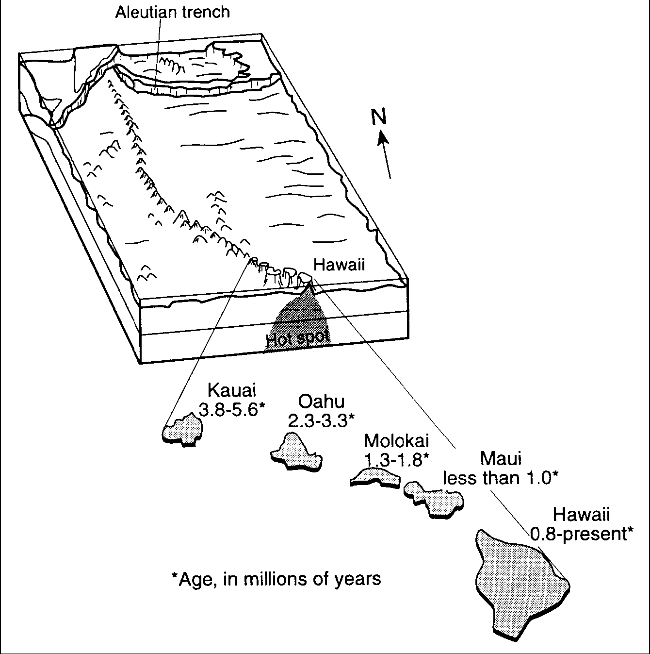
32. On which plate is the Hawaiian Hot Spot located?
Pacific
African
Nazca
North American
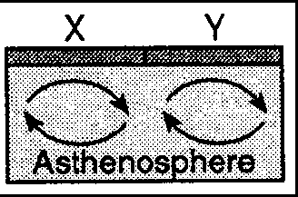
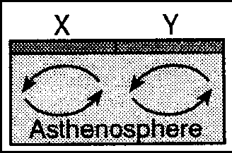
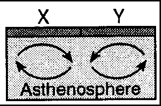
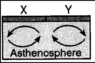
33. Which cross-sectional diagram of Earth’s asthenosphere best shows
the convection currents that would cause crustal plate X to away from crustal
plate Y?
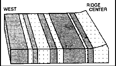
34. Which evidence causes most scientists to believe that seafloor
spreading occurs at the mid-Atlantic Ridge?
Oceanic crust on both sides of the ridge shows matching patterns of
reversed and normal magnetic polarity.
Oceanic crust on both sides of the ridge is less dense than continental
crust.
Large sedimentary folds exist in the mantle near the ridge.
Oceanic crust is oldest at the ridge.
35. Which inference is supported by a study of the Earth's magnetic
rock record?
The Earth's magnetic field is only 2 million years old.
The Earth's magnetic field is 50 times stronger now than in the past.
The Earth's magnetic poles are usually located at 0 latitude.
The Earth's magnetic poles appear to have changed location over time.
36. What happens to the density and temperature of rock within Earth’s
interior as depth increases?
density decreases and temperature decreases
density decreases and temperature increases
density increases and temperature increases
density increases and temperature decreases
37. What usually causes tsunamis?
hurricanes
high-pressure weather systems
undersea earthquakes
the collision of ocean currents
38. Base your answer on the diagram below.
What do all four rock samples have in common?
The are organically formed.
The formed on the Earth's surface.
They show cleavage.
They contain minerals.
39. The block diagram below shows the bedrock age as measured by
radioactive dating and the present location of part of the Hawaiian Island
chain. These volcanic islands may have formed as the Pacific Plate moved over a
mantle hot spot.
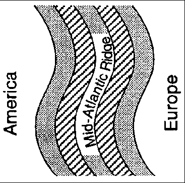
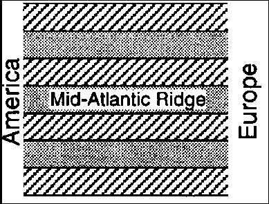
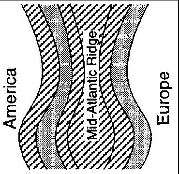
40. Which map best represents the general pattern of magnetism in the oceanic bedrock near the mid-Atlantic Ridge?

41. A seismographic station determines that its distance from the
epicenter of an earthquake is 4,000 kilometers. According to the Earth Science
Reference Tables, if the P-wave arrived at the station at 10:29 a.m., the time
of the earthquake's origin was
10:08 a.m.
10:22 a.m. (2) 10:02 a.m.
10:10 a.m.
42. What happens to the velocity of P-waves and S-waves if there is an
decrease in the density of the materials that they are traveling through?
The P-waves slow down, but the S-waves speed up.
The P-waves speed up, but the S-waves slow down.
Both the P-waves and the S-waves speed up.
Both the P-waves and the S-waves slow down.
![]()
Base your answers to questions 43 through 47 on the Earth
Science Reference Tables and the diagram below. The diagram shows the magnetic
orientation of igneous rock on the seafloor on the east (right) side of a
mid-ocean ridge. The pattern on the west (left) side of the ridge has been
omitted. The age of the igneous
rock and its distance from the ridge center are shown.
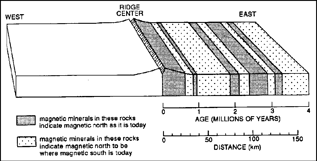
43. As distance from the center of the ridge increases, the age of the
rocks
decreases.
increases.
remains the same.
44. According to the diagram, what is the approximate rate of seafloor
spreading?
1 km/million years
40 km/million years
2 km/million years
50 km/million years
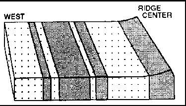
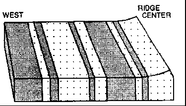
45. Which diagram below best represents the pattern of magnetic
orientation in the seafloor on the west (left) side of the ocean ridge?
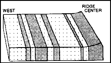
46. Which inference can best be made from the diagram?
The amount of fossil material preserved in the igneous rock has changed with
time.
The elevation of sea level has changed with time.
The size of the continents has changed with time.
The orientation of the Earth's magnetic field has reversed with time.
47. The occurrence of high-heat floors at the ridge center provides
evidence of the
destruction of oceanic crust.
destruction of continental crust.
existence of ancestral mountains.
existence of rising mantle convection currents.
![]()
48. The cutaway diagram below shows the paths of earthquake waves generated at point X.
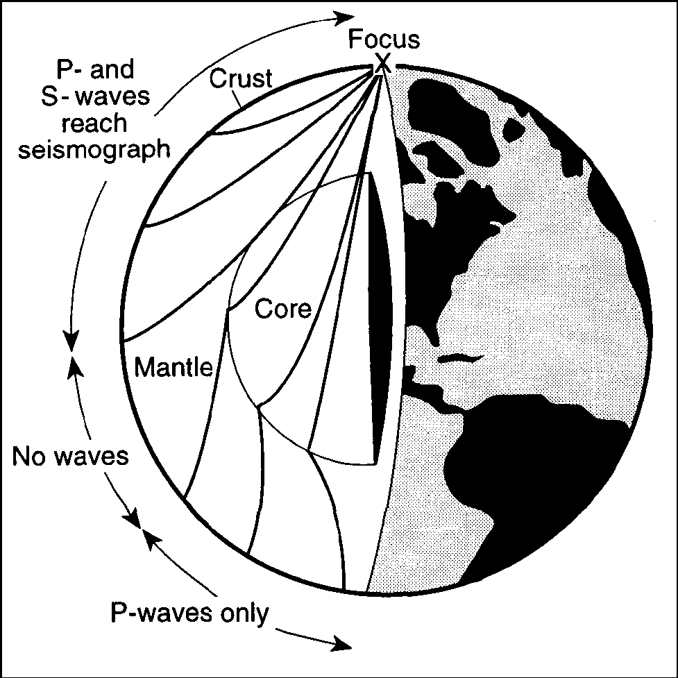
Only P-waves reach the side of Earth that is opposite the focus because P-waves
can travel through liquids and S-waves cannot
travel faster than S-waves
travel faster than S-waves
are stronger than S-waves
49. Which ocean current carries cool water toward Earth’s equator?
Alaska Current
Peru Current
East Australia Current
North Atlantic Current
50. Active volcanoes are most abundant along the
edges of tectonic plates.
eastern coastline of continents.
23.5° N and 23.5° S parallels of latitude.
equatorial ocean floor.
51. Which part of Earth’s interior is inferred to have convection
currents that cause tectonic plates to move?
rigid mantle
outer core
asthenosphere
inner core
52. Compared to the continental crust, the oceanic crust is
less dense and less felsic.
less dense and less mafic.
more dense and more felsic.
more dense and more mafic.
53. Which rock is sedimentary in origin and formed as a result of
chemical processes?
granite
breccia
shale
dolostone
54. The igneous rock is mostly composed of potassium feldspar and
quartz crystals that
have an average grain size of 3 millimeters. The igneous rock is most likely
granite
gabbro
pegmatite
pumice
55. The data table below shows the density of four different mineral samples.
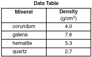
A student accurately measured the mass of a sample of one of the four minerals
to be 294.4 grams and its volume to be 73.6 cm3. Which mineral sample did
the student measure?
corundum
hematite
galena
quartz
56. Which mineral has a metallic luster, a black streak, and is an ore
of iron?
galena
pyroxene
magnetite
graphite
57. The edges of most lithospheric plates are characterized by
reversed magnetic orientation.
unusually rapid radioactive decay.
frequent volcanic activity.
low P-wave and high S-wave velocity.
58. Compared to Earth’s continental crust, Earth’s oceanic crust is
thinner and more dense.
thinner and less dense.
thicker and more dense.
thicker and less dense.
59. Which statement correctly compares seismic P-waves with seismic
S-waves?
P-waves travel faster than S-waves and pass through Earth’s liquid
zones.
P-waves travel faster than S-waves and do not pass through Earth’s liquid
zones.
P-waves travel slower than S-waves and pass through Earth’s liquid zones.
P-waves travel slower than S-waves and do not pass through Earth’s liquid
zones.
60. A seismograph station recorded the arrival of the first P-wave at
7:32 p.m. from an earthquake that occurred 4,000 kilometers away. What time was
it at the station when the earthquake occurred?
7:20 p.m.
7:32 p.m.
7:25 p.m.
7:39 p.m.
61. Which temperature is inferred to exist in Earth’s plastic mantle?
2000°C
5000°C
3000°C
6000°C